Kaggle Datasets: collaborative open data

Dan Fowler over at the OKFN frictionless data chat posted a link to an interesting initiative: Kaggle Datasets.

Kaggle is a platform for learning about, teaching and collaborating on all things machine learning. Users upload data, write and share analysis/visualisation algorithms (called kernels) and participate in challenges. Members are encouraged to share their code with others and review and comment on their fellows’ work. Kaggle is, in a way, a platform for collaborative learning.

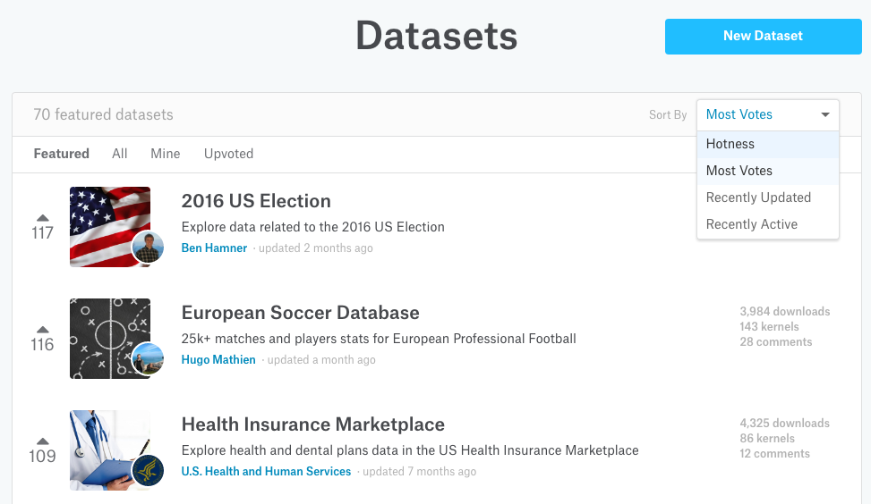
Datasets is a newly launched feature that adds collaboration functionalities to the hosted datasets. Users are able to upload, share, discuss and explore data by crafting and sharing kernels. Datasets is fairly unique in that it brings data, algorithms and users together in one place. Users can vote and comment on almost anything, making the kernels/datasets legible. Kernels run in the browser making them and the dataset they operate on extremely accessisble and actionable.

Screenshot 2016-09-01 15.11.34.png

Kaggle’s Datasets bring to data (science) what GitHub brought to software: open frictionless collaboration.

Read more


Carefree and social open data hacking

N.B. This blog post was written for the Hacking for Sustainability Challenge. It outlines the measures we took and the tech we deployed to ensure #carefreehacking for the participants such as thorough data preparation and numerous open feedback channels. 

Hacking for Sustainability streeft naar #carelesshacking: we willen we je zoveel mogelijk helpen om snel en effectief je cutting-edge data-driven analyses, visualisaties en apps te realiseren. Vanuit onze eigen open data ervaringen weten we dat het zoeken, opschonen en verrijken van open data een tijdrovende (en soms frustrerende) bezigheid kan zijn.

Het grote aantal data portalen en datasets, het matige niveau van de documentatie, de onbekende naamgeving en terminologie (zoek je naar “lantarenpaal” of “lichtmast”?), het ontbreken van eenvoudig te gebruiken APIs en homogene dataformats maken het omgaan met data een ware beproeving.

Één manier om deze obstakels te overwinnen is door ze gezamenlijk op te pakken.

Read more


“The UK Government Digital Service is dead”

N.B. This blog post has turned into an archive for post-GDS analyses. I’ll add more articles as I encounter them on the web.

David Eaves describes on Medium how and why the British Government Digital Service met its (in practical terms) demise.

GDS represented a centralization of IT control, and the departments — for whom GDS frequently found savings of tens of millions of pounds and provided effective online services on behalf of— didn’t like seeing their autonomy and budget sucked away by a group of IT geeks.

I suspect the existence of GDS and its global network has activated a global counter-movement among senior mandarins.

… if you work for a digital service outside the UK, it is time to go double down on political cover and/or to reach out to the senior public servants around you and build some alliances.

The empire of traditional siloed bureaucracy is fighting back. You probably won’t beat it. So how are you going to engage it?

Government (digital) innovation is a topic near and dear to my heart. I’m greatly saddened by this chain of events and sincerely hope that other initiatives won’t face the same fate.

Read more


Participatory urban planning with Minecraft

In my research I’m looking for ways in which geographical information science and technologies can help citizens to more effectively participate in urban planning processes. The holy grail of participative urban design is allowing citizens to co-design urban interventions in 3D game-like environments.

Designing cities in 3D is becoming fairly trivial; an ever-increasing number of advanced city building tools are emerging that employ the latest in 3D technologies. In esri’s CityEngine, for instance, you create cities like you do in SimCity: draw a bunch of roads and the buildings automatically pop-up around them. While extremely powerful, CityEngine and its brethren are ill-suited for citizen-dominated design sessions. These require simple and immersive tools with limited design options that allow citizens to quickly and intuitively sketch their ideas without technology getting in the way of the discussion and deliberation process.

We ran a number of participatory planning workshops in which CityEngine was a communication tool of sorts, a canvas for an explorative discussion between citizens. We discovered that CityEngine

__ is a complex beast; one needs considerable training to get started
__ is difficult to navigate, especially for non-experts. Even if you model a city beforehand, citizens are unable to use CE on their own to support their arguments during a discussion
__ is great for building fantasy worlds and non-existent cities. However, it takes considerable effort and knowledge to rebuild existing urban areas with the right amount of detail. Too much detail and people start to pick on and discuss small irrelevant details; too little detail and citizens do not accept the 3D abstraction and fail to engage with it in a meaningful way

Even though one can fathom remedies for these barriers by e.g. employing a modeling expert to translate citizens’ ideas into a CityEngine design, we seek instruments that enable citizens to craft a plan of their own with as little assistance as possible. These tools should furthermore be deployable in real-world circumstances: few municipalities and governmental institutions have the human and financial resources to create proper canvases in CityEngine, let alone use these during deliberation sessions.

We were thus thrilled when we stumbled on the Block by Block project: participatory urban planning using… Minecraft!

Read more


tourism=yes

tl;dr I made a map that shows all Bulgarian OpenStreetMap buildings that sit within Bulgarian nature areas.

Bulgaria is a beautiful country brimful with amazing nature: it has great mountains to hike, expansive plains with cute villages and cosy towns to visit and a beautiful Black Sea coast fit for relaxing in the sun.

I’ve seen a fair share of Bulgaria’s natural beauties. We grew up in the capital Sofia and climbed the nearby Vitosha mountain regularly. In the last couple of years we hiked across the major mountains Rila, Pirin, The Balkan and Rhodope Last year we switched the hiking boots for wheels and cycled along the south coast and into the beautiful Strandzha region.

All this beauty is, sadly, under constant threat of being built on. At first you are oblivious to this threat; you see a luxurious mansion on a beautiful spot high in the mountain and are envious of the lucky owner.

Read more